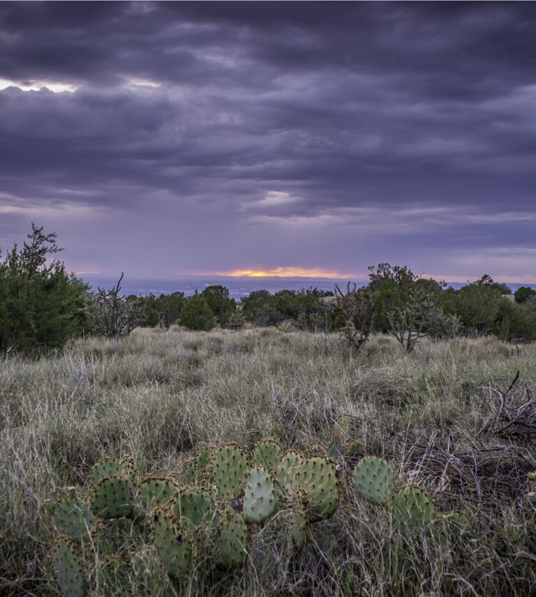
The city falls away and the freeway rolls up beneath our car, and Tijeras Canyon appears suddenly on every side. This is the road to where we want to go, but it’s also a place all on its own.On the left, the southern end of the Sandia Mountains clatters motionlessly down to the freeway’s edge, a sloping jumble of boulders. On the right, the north end of the Manzanita Mountains stands parallel to Interstate 40, a dusty slant. Between them and the road runs Tijeras Creek, as it has since Ancestral Puebloans planted corn in wide yellow lines on either side of it. On the left, the old Spanish village of Carnuel sprawls among rocks—a house here, a house there, boulders between them all. There’s the old church, and there’s a white cross on a stony peak. Later, on the right, down below the road, a broken bridge crumbles among weeds, once a turn on Route 66, route of tourists in Model Ts and Okies fleeing the Dust Bowl.Soon, an exit on North Highway 14, and soon, on either side of the road—the mountains—and the village of Tijeras. We’re in the Sandias now. Everywhere there is grass, and there are trees, and the rise of the mountains. Oh, and there’s also an enormous, castle-sized cement factory and a strip mine.The mountains continue to rise on the left, and the world continues to green. There’s a rise, and on the left, there’s Penny Lane, home to what’s left of the Well Country Camp, the area’s first tuberculosis sanatorium. On the right, there’s the ridge, La Centinela, where Apaches once watched the wagon road below. There are San Antonio, Cedar Crest, Cañoncito and Sandia Park—mountain towns—but we will leave these mountains behind.Continuing north, we pass through the little village of San Antonito—founded after a feud among the residents of San Antonio—and the world opens up. We turn left onto La Madera Road and follow the winding pavement. This is the woods road, and soon we’ll come to its namesake—La Madera. There’s the old church, now turned into a house. There’s the old dancehall, now crumbling into its basement, a dream of splintering wood and sun-cracked adobe. People used to ride their horses or walk from miles away for the dances here—women would set their nursing babies beneath the wooden benches—and everyone would dance to live fiddle and guitar. This was a woodcutting and farming town. We cross a cattle guard, and the road turns to dirt, and the road winds down along the edge of a grassy valley. The land is becoming sandstone now. Rabbitbrush blooms yellow amidst fields of cholla cactus and cottonwoods—sandstone heaps and mud slot canyons and volcanic cliffs. Off somewhere on the left, lie the foundations of Tejon—one of two area towns (along with Carnuel) named after badgers. Tejon was a bean-farming and gypsum-mining community in the 1800s, a community that might still be around if a politically-connected livestock baron hadn’t acquired all of the area’s grazing and water rights and then forced out the entire community. Off on the right somewhere are the faint traces of Uña de Gato, now nothing but heaps. Both communities have cemeteries. Adolf Bandelier, namesake of Bandalier National Monument, once stayed in Uña de Gato and was told of a local boy killed by a wolf. Most of his notes on that stay, however, are just a lot of complaining about the wife of his host. She was annoying. The road is lined with ruins and ghost towns and secret things. The hills behind everything hide old mines, names and dates and pictures carved into rocks, ancient piles of rust and glass. An abandoned ranch from the 1950s. A house with the roof burned away and its inside filled with trees, an indoor forest. A nameless settlement beside a little waterfall. On the right, after a time, the walls of the road’s best-known former town suddenly reveal themselves. Hagan. Its largest building, the mercantile, has walls more than two stories high, and it was once the largest adobe building in the Southwest. In the 1920s, several hundred people lived and worked here, mining coal in the more-than-seven miles of tunnels that still lay empty beneath it. There are mines, a power plant, a hotel, a school—the desert quietly reclaiming them all. Now cows graze beside a house where a baby was once born, and the sky settles into the roofless home of the town’s wealthiest man. Three miles on, on the right, sit the ruined outlines of Coyote, Hagan’s sister city. Hagan and Coyote both waited for the railroad, but by the time it came, Coyote had mostly gone away. Coyote’s mostly built around a single long swell of white sandstone, a swell dappled with carved names from another time.Past Coyote, with the green crest of the Sandias off to the left and the black peaks of the Ortiz Mountains—home of the West’s first gold rush—off to the right, the road crosses onto San Felipe Pueblo land. Here, somewhere off to the left, pre-European native mines can still be seen, as can the remains of Tonque Pueblo, once perhaps the most thriving settlement in the Rio Grande Valley. They were pottery makers and traders, and their city lasted longer than Albuquerque has. Nothing is permanent. Here, the second Spanish expedition into New Mexico stopped in 1581, and here a priest left the expedition before quickly being murdered. And beside the Pueblo are the ruins of the old Tonque brick factory, dating to the early 1900s. La Madera Road and its environs are a microcosm of Southwestern history, which is one reason I love it so much. Really, the entire area should be a national or state park. Everything is around it, from ruined Pueblos, to Spanish villages, early 20th-century coal mining towns, 1950s ranch houses and modern homes. But the area is also a microcosm of my own world. I grew up in Cedar Crest, and from the age of 15 on, I explored the road with a hunger. My younger brother and I drove the road every night during an especially challenging time in his life. I was married in a cactus field along it, though that didn’t quite work out. My 5-year-old son is named after Hagan. The musician Soltero wrote a song about me and the road (“Michael”). And two years ago, I found a wall of carved crosses—and a name, “Santa Maria”—seemingly dating back to 1581, perhaps the oldest Spanish inscriptions in America. That discovery made national headlines, and it’s still the coolest thing I’ve ever been part of. It’s an important place to me—it feels like the inside of my being, if my innermost self was a landscape. When people like it, I feel understood.La Madera Road is a public right of way, but much of the land on either side of it is private ranch land or native land, and special permission is required to legally visit. So let’s continue on, until San Felipe Casino—a jarring neon sight at the end of all this timeless desert. Here we can get onto Interstate 25 and head south, back to Albuquerque. We’ve now circumnavigated the Sandia Mountains and seen a bit of what lies beyond them. We’ve seen that whole lives and the places that contain them can just crumble away into the desert—and maybe that makes the city seem more uncertain now. Or maybe it shows it to be a part of something much larger: something as big as all history, all the West, all of space and all of time.
Road To Somewhere: Tijeras Canyon, The Sandia Mountains—And La Madera Road
Tijeras Canyon, The Sandia Mountains—And La Madera Road
7 min read
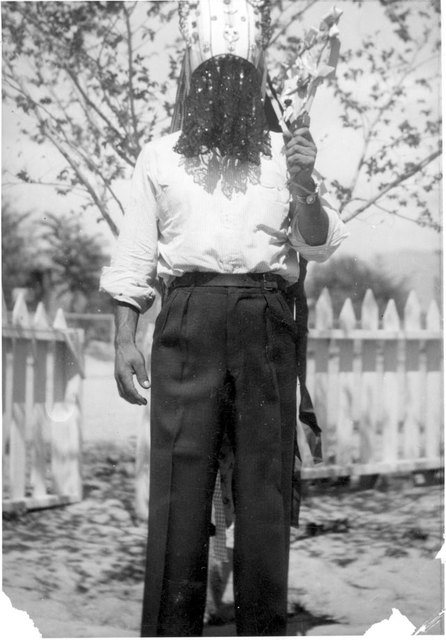
A Matachine dancer in San Antonio, NM, in the 1920s
Towns of the Sandia Mountains Project