Parched?

Albuquerque’s Drinking Water Project Goes Into Effect Next Year. Do You Know What’s In Your Glass?

Christie Chisholm
\
20 min read
Steve Harris at the Middle Rio Grande Decision-makers Field Conference in Socorro earlier this month. (Ron Gardiner)
Share ::
“Doesn’t it taste great? If you didn’t know better, you’d think it was Aquafina!”

A perky woman with shoulder-length brown hair and an expectant smile stares across the table at a young woman, who sniffs the water bottle in her hand after a cautious sip. She nods.

“This is surface water that’s been treated to remove contaminants.” The smile grows. “Now the aquifer will be like a savings account instead of a checking account!”

The young woman turns the bottle in her hand. On its label it reads: “In 2008, the Drinking Water Project will begin diverting San Juan-Chama river water to a new, state-of-the-art treatment plant … Once purified, the San Juan-Chama water will be distributed to our customers for drinking water …”

The “customers” the bottle—a marketing device from the Albuquerque Bernalillo County Water Utility Authority—refers to are the residents within Albuquerque city limits. The way the water will be “distributed” is through our faucets.

The bottle is a preview of the city’s soon-to-be tap water. It’s also a representative of one of the most significant changes modern-day Albuquerque has ever undergone: switching from groundwater to river water. The shift sounds easy enough, but the issue is anything but simple. And with an appeal to the project filed earlier this month, Albuquerque’s water future seems uncertain.

The young woman sets down her bottle and reaches for a comment card. At the same time, an elderly woman stands up to leave, ready to continue her Friday-morning mall shopping.

“Did you like it?” The smile grows larger still.

The older woman raises her eyebrows and shrugs, “Tastes the same to me.”

“Well, that’s what we’re hoping for.”

Draining Lake Superior

In 1984, the City of Albuquerque placed an ad in the New Yorker and other national magazines as part of a campaign to attract residents and bolster economic growth. The ad was a picture of downtown Albuquerque, backdropped by the Sandias. In the foreground sloshed a large lake with a lone yellow-and-red sailboard.

In white letters stretched across the lake the ad posed a request: “Name a great American city on a large body of water.” The answer lay underneath in bold: “Albuquerque.” It went on: “Each year, the Rio Grande Basin, an underground lake larger than Lake Superior, yields more than 32 billion gallons to the city’s wells serving nearly 400,000 people. At the projected rate of growth, the city’s present water rights holdings, which enable Albuquerque to tap this vast underground lake, will be adequate well into the 21
st century.”

This boundless body of water was going to support our city for generations to come. And it would be another decade before the dream was proven false.

The catalyst for our shift in understanding came in 1992 with a study published by hydrologists J.W. Hawley and C.S. Haase entitled
A Hydrological Framework of the Northern Albuquerque Basin . The study showed that the reservoir beneath Albuquerque was not, after all, one giant pod filled with water, but a fractured network of water-filled vessels, some easier to reach than others, some with impure water.

Additionally, prior to the study the Rio Grande and the aquifer were thought to be directly linked. The city purchased San Juan-Chama water in 1963 with the intention of using the river water as an offset to Albuquerque’s groundwater pumping. The San Juan-Chama water was diverted to the Rio Grande, and the theory went that the extra water from the river would seep back into the aquifer, replenishing much of what the city pumped out every year. The Hawley and Haase study, however, showed the aquifer-river connection was somewhat weak. Although the river still replenished the aquifer, it did so at a much slower rate than previously thought.

The second blast came the following year when the U.S. Geological Survey (USGS) released a groundwater flow report of the Albuquerque Basin, showing that recharge in the aquifer was only occurring near the river and not in most of the areas pumped by the city. The city had been developed without thought to recharge, and areas that used to serve as conduits to the aquifer (arroyos, the base of the mountains, the river floodplain) were paved with concrete and asphalt, preventing water from seeping into the earth. The city was pumping four times as much groundwater as was being replenished, and, over 30 years, had sucked out a massive amount of water from the aquifer, lowering its levels by as much as 140 feet in some parts of the city. Lake Superior was drying up.

“We were drawing down five feet a year. When you get to 250 feet, you have problems. Parts of town start to sink a little.” John Stomp pauses, glances at a blown-up, framed copy of the city’s old
New Yorker ad hung by his desk. “Now with conservation, we’re at two to two-and-a-half feet a year. But once compaction happens, it doesn’t come back.”

Stomp is the manager of the city’s Water Utility Department and the head of the San Juan-Chama Drinking Water Project, the initiative that’s supposed to solve Albuquerque’s water problems. “We’re predicting that over the next 40 years, the aquifer will rise at least 25 feet.”

The reason for Stomp’s optimistic estimate is the Drinking Water Project, which is due to go into effect July 2008. When it does, the city will slowly start weaning Albuquerque off groundwater and onto river water. The change is significant.

If you walk over to your kitchen faucet and turn it on, what will come out is 10,000-year-old water, pumped from under your feet. Little more than a year from now, do the same and you’ll be looking at an entirely different source of water—runoff from the mountains of southern Colorado, diverted here from nearly 200 miles away. The change won’t be instantaneous. The river water will be mixed with groundwater but, over time, less and less water from the aquifer will be used. Within the next couple years, the city’s primary source of water will be the San Juan-Chama.

The plan for the project started to form after the release of the two studies. The city jumpstarted its conservation program in 1994. Before the program started, the city was consuming an average of 250 gallons of water per person per day (imagine 250 milk cartons stacked on top of your lawn, in your shower, teetering out of your toilet). Last year, the number had dropped to 165 gallons per person per day, which still sounds like a lot.

“The standard home uses 90 gallons per person per day,” Stomp explains. “If you run a hose, it’s shooting out five gallons a minute. But to get the average you add on commercial businesses, schools, hospitals.”

While the city was instituting its new conservation program, it was also crafting a “Water Resources Management Strategy” intended to solve the problem of the shrinking aquifer. What it came up with was more conservation, recycling … and the Drinking Water Project, adopted by the City Council in 1997.

The project would cost $400 million and be funded with rate increases on residents’ water bills. (Unfold your bill and look for the “Sustainable Water Fund” on the second line.) By the time the final plan was crafted, it involved a couple new pump stations and miles of pipelines to move the river water in and out of the system, a diversion dam on the Rio Grande just south of the Alameda Bridge, and a water treatment plant on Montaño to clean the water before it reached our hoses.

The Drinking Water Project works by taking the San Juan-Chama water the city bought in the ’60s and, instead of using it to offset groundwater pumping, using it to replace or supplement groundwater pumping. Last year, the city pumped about 100,000 acre-feet from the aquifer. (An acre-foot is the amount of water it takes to cover one acre of land in one foot of water. One acre-foot equals 325,851 gallons.) The Rio Grande pushes through about 1 million acre-feet every year (325 billion milk cartons), and the San Juan River twice as much.

According to the city’s 1963 purchase, Albuquerque has rights to as much as 48,200 acre-feet of San Juan-Chama water every year. In years when the run-off in the river is low, the city will get proportionately less water. It’s these years when the city will fall back on the aquifer, using groundwater to make up the difference.

Whatever amount of water the city gets in a given year will be mixed with an equal amount of water from the Rio Grande, purified at the water treatment plant and sent through the city’s drinking water system. The Rio Grande water is added to make up for water leakages and evaporation in the system, ensuring that “every last drop” of the San Juan-Chama water is used. Since about half of the water that comes out of city faucets is actually used (the rest is flushed down toilets and drained in showers and sinks, then treated as effluent and returned to the river), the Rio Grande water added to “carry” the San Juan-Chama water through the system is eventually returned to the river.

Of course, by the time the San Juan-Chama water reaches our part of the Rio Grande, and certainly by the time it’s coming out of our faucets, there’s no telling which molecule of water came from the San Juan and which from our river. (“There’s no red water and blue water,” says Stomp.) Yet the city is still legally obligated to keep track of its “San Juan-Chama” water, and so the mixed river water is still thought of in these terms.

The goal of the project is to keep Albuquerque hydrated without killing the aquifer. By using a steady flow of river water, the idea is to give the aquifer a break, time to slowly recharge, and halt the city’s path toward subsidence.

“As long as water comes through the basin, we get half of it, we can use it in perpetuity,” says Stomp, a somber expression stretching over his face. “If we don’t use the San Juan-Chama water, we will destroy the aquifer. And it’s about more than Albuquerque. We’re drawing down Sandia Pueblo’s aquifer at one-and-a-half feet a year. We’re drawing down as far out as Socorro. It’s a huge, basin-wide problem. How could that be better?”

Stomp is defensive now. He’s been nursing the Drinking Water Project for the last 10 years, and every step of the way the project’s been met with opposition, although it hasn’t drawn much publicity. He’s thinking of that opposition now, and an appeal that was filed against the project just a few days before.

“The court of appeals issue is very serious. I’m not sure what would happen.” He stops. Several seconds pass. When he starts again, his voice is resolute. “Obviously, we have a lot riding on this—we’ve put in a lot of time and effort to get it done. We would appeal. We have a good project; I’m sorry they don’t think so. It’s a big deal.”

Sucking Rights

Lisa Robert sits back in her chair and swings her feet onto a splintery patio table. Once settled, she looks toward the trees and continues listing the birds that frequent her five acres of land in Tomé.

“Let’s see, there are pheasants, swallows, king birds—they like to nest in the windmill—doves, several kinds. That melodic singing is a Western meadowlark. There are sparrowhawk babies under the eves. Sandhill cranes come through here, snow geese, curlews, ibis. This is ag [agricultural] land, but the environmentalists are blown away by the birds here.”

Robert’s land has been growing alfalfa for 150 years, 19 of which she’s overseen. But she doesn’t cultivate it to turn a profit. The crops feed three horses and her son’s cow. “It’s more about hanging onto it. I’m committed to holding on because the bottomland is the only place where water still percolates to the aquifer naturally. Irrigation in this valley is part and parcel of the river system. It’s a surrogate to the river.”

If the activity in Robert’s neighborhood is any indication, those bottomland connections are dwindling. “There are 16 acres across the road, and my neighbor has eight.” Then Robert looks past the 16 acres to a large sign that’s been erected down the road, signaling slated development. “That big field has been subdivided; there’s going to be a lot of houses on it.”

Robert has been writing about water issues in New Mexico for more than 20 years. She’s the former editor of the
New Mexico Water Dialogue and a key player in regional water planning. In 2005, she authored the update to the Middle Rio Grande Ecosystem Bosque Biological Management Plan , a comprehensive review of water issues along the Middle Rio Grande and recommendations for action. She’s also among the plaintiffs in the appeal against the Drinking Water Project.

The appeal is just the most recent skirmish in a long battle. When the City of Albuquerque filed an application in May of 2001 for the permit to divert their San Juan-Chama water for the project, Robert was one in a large group—consisting of pueblos, individual citizens, government entities, and a coalition of agricultural and environmental groups—who filed a protest against it a few months later. It wasn’t until July 2004 that the permit was approved, but the group (or what remained of it—most plaintiffs settled with the city and dropped the case) followed close behind and filed a motion to dismiss the city’s application soon after in district court. In 2006, the court denied the motion. Then, on Thursday, May 17, 2007, an appeal to the district court case was filed. The only remaining plaintiffs belong to the coalition: Amigos Bravos, Rio Grande Restoration, an individual citizen named John Carangelo and the Assessment Payers Association of the Middle Rio Grande Conservancy District, the group to which Robert belongs.

What the appeal—and every other legal action the coalition has brought over the last six years—asks for is that more conditions be put on the city’s permit. As it stands, the group argues, Albuquerque’s Drinking Water Project threatens to impair existing water rights, work against public welfare and conservation in the basin, and jeopardize the compulsory delivery of water to Texas under the terms of the Rio Grande Compact.

Robert slides her feet off the table and sits up, shaking her head. She’s talking about the effects of the project on the 17 miles of the Rio Grande between where the water will be taken out, treated and run through the system (at Alameda) and where it will be returned as effluent (south of Rio Bravo); the stretch that’s about to get as much as 100,000 acre-feet of water less a year than it’s used to.

“That 17 miles of river is going to be robbed of 100,000 acre-feet of water,” she says, “and it will suffer consequences. If the water table drops, valley cottonwoods will start to die, and some domestic wells could go dry. The state’s not responsible for that; people will simply have to drill new wells.”

Robert pauses. “There are a lot of social, environmental and legal ramifications to taking that much water out of the river. The system’s been used to having it for 30 years, and uses have been created around it. You can’t just take it out without consequences.”

Bill Miller is a hydrological engineer who was hired as a technical consultant to the coalition in 2001. Large parts of the cases the group filed are based on his findings, which are, to say the least, unsettling.

“A fair amount of this water has been in use since 1973,” the year the San Juan-Chama water began being diverted to the Rio Grande. “Every year the city has been getting water from the Colorado River basin and storing it in reservoirs around the state—Jemez, Elephant Butte, Abiquiu Reservoir—it’s lent it to farmers in the Conservancy District, lent it to the Bureau of Reclamation for the silvery minnow. All that water going down the river now, in lakes, will be diverted and consumed. The impact isn’t fully addressed.”

Another issue on Miller’s mind is what will happen to senior water rights holders (entities who used water from the river prior to 1907—mainly tribes and acequias) after the project begins. The river-aquifer connection does exist, although not as immediately as originally thought, and the water drawn from the aquifer still affects the river.

Imagine a bottle with a funnel placed in its opening. If you pour enough water into the funnel, you’ll not only fill up the bottle but eventually fill the funnel to its rim. If you then poke a hole in the bottle and drain some of the water, the amount of water in the funnel will also decrease. The river-aquifer connection works in a similar, although much less immediate way. When water is pumped from the aquifer it leaves a void in the system. The void will eventually be filled by the river, thereby diminishing surface flow.

Even though the city wants to drastically cut pumping from the aquifer, the effects on the river will still be seen for many years. Also, as less groundwater is pumped, less water from the aquifer will be discharged to the river as municipal effluent, which is currently treated and sent downstream to irrigators like Robert. Over time, reduced pumping could help replenish the aquifer, but it will mean less water in the river for downstream users.

“The impacts of pumping take a long time to manifest on the river,” explains Miller, who is also a former Interstate Stream Commission engineer. “For instance, if you pump 100 gallons on San Pedro, it ultimately comes from the Rio Grande, but it could take 20 years to see. The water the city pumped from wells in 1975—the effects are still being seen on the river. There’s a time delay involved.”

Printed on the label of the water bottles the city handed out at the mall, in bright blue letters, is the slogan of the Drinking Water Project Campaign: “The Sustainable Solution.” Yet Miller believes the slogan is only a half-truth.

“It’s more complex than saying they’re taking water from the river and it will always be there,” Miller says. “Ultimately, they need a sustainable use of groundwater. All these years we’ve been pumping, since the ’30s. We pump it out of the ground, we flush it, it goes back to the river and is gone forever. Instead of treating the water like sewage and getting rid of it, we should treat the effluent and put it back in the ground. People in California and Arizona have projects like that. It’s more expensive, but how much are you willing to pay for a glass of water?”

If you’re Steve Harris, the answer is quite a lot. Harris is a co-founder of Rio Grande Restoration and the organizer who got the coalition together in 2001 to protest the city’s application. As someone who’s been working with Rio Grande water for more than 35 years as a river guide and who’s been involved in regional and state water planning, he’s got a lot to say on the issue of how society should treat such an elemental resource.

“Conservation’s a pretty complicated subject,” he says, voice rumbling over the phone from his home office in Taos. “We’re using a tremendous amount of this precious resource—treating it at great cost, distributing it, depleting it. Our demands are excessive. We flush five gallons down the toilet, rely on evaporative coolers, we have lawns, all demand water in excess of what the system can provide.

“The equivalent of another Rio Rancho is about to spring onto the horizon in the next 10 years,” he adds, referring to SunCal’s recent acquisition of 55,000 acres of Atrisco land on Albuquerque’s Westside [See: Feature, “Atrisco’s Long Goodbye,” Jan. 18-24]. “We can’t afford it. Who’s going to pay the water cost? Who’s going to bear the pain? Not Albuquerque—the people and living creatures downstream. It’s not fair. When the disruption of supplies becomes manifest, things are going to get ugly.”

A Three-Inch Difference

Back in an office overlooking Civic Plaza, Stomp considers some of the claims made against his project. It doesn’t take long for him to craft a retort.

“We tried to develop a project that would preserve and protect the environment. We’re responsible for monitoring the effects on the bosque for 20 years. If something happens we don’t see coming, we’re responsible for that.” Then, emphatically, “This is the most stringent permit ever issued in the state of New Mexico.”

Most of all, he says, the project won’t affect flow to downstream users, pointing out that the diversion has to be shut down during low river flows and that the city is required to “instantly and instantaneously” put back the same amount of water it’s diverting.

As to whether there will be impact to users along that soon-to-be low-flow 17-mile stretch, Stomp says, “No one really know if there will be an impact,” but he insists the city has calculated a maximum of a simple three-inch difference in the water table in the corridor.

What about the projects the San Juan-Chama water’s been supporting?

“When we had excess, it made sense to sell it for the minnow, to give it to farmers,” he says. “It’s water we’ve been nice enough to give away—we never asked the farmers to pay [note: The Conservancy District is required to pay the city back in water what it was given]; we gave it to them because it was the right thing to do. But the concept of what was right changed in 1994.”

Stomp stops, glances back at the New Yorker ad mounted on his wall.

“Things change.”

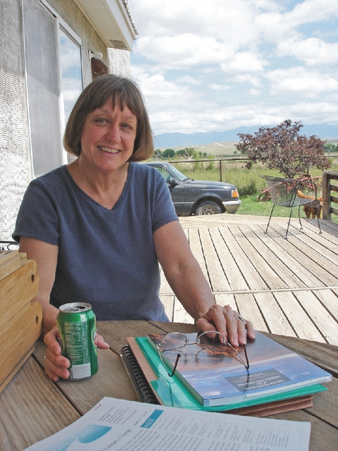
Lisa Robert on her front porch in Tomé, N.M.
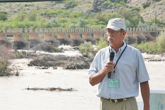
Christie Chisholm

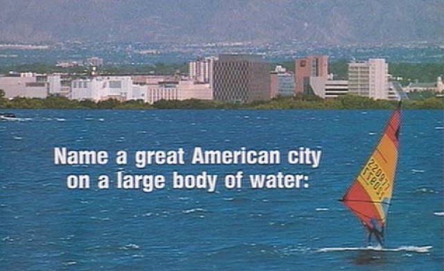
The top part of an ad the City of Albuquerque ran in national magazines in the early ’80s to attract residents and bolster economic growth.

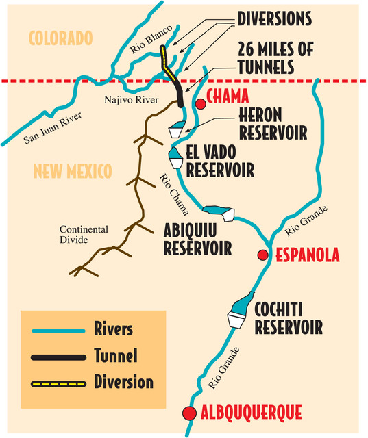
A map of how water from the San Juan River is diverted the the Rio Chama (making it San Juan-Chama water) and then to the Rio Grande, traveling nearly 200 miles before it reaches Albuquerque.

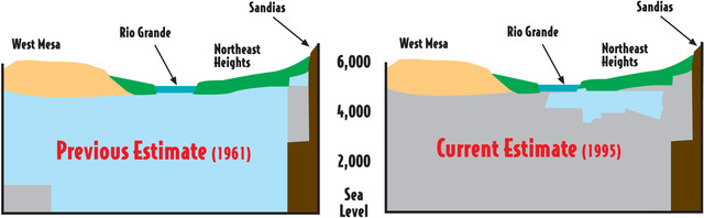
Conceptions of what people thought the Albuquerque aquifer looked like pre-1993 (left) and what it actually looks like.

1 2 3 214

Search